I was assigned to Moselle Control for 3 1/2 years (1963-1966) while the USAF was assigned to NATO. First of all, it was a tri-party operation, the USAF, the French AF, French civilians, and the RCAF. The Commandant of the fort was alternated every year ( USAF, FAF, RCAF). Fort Jeanne D’Arc was an air traffic control center controlling all air traffic in the corridor between Paris and Berlin. Hence our name for the fort was Moselle Control. We also just called the "Hill" because from Metz to the fort as I recall once we headed toward it there were a lot of winding roads going up to get to it. I do not recall the altitude but it was much higher than centreville de Metz. I haven’t seen a topo map of the area yet but possibly it was in the beginnings of the Vosges. At Moselle (fort JD) we had Search and Height Finder Radar on top of the fort, tri-party air traffic controllers (2nd level inside), American Radar Maintenance (2nd level inside) and American Ground to Air Radio Maintenance (bottom level inside). I was in charge of Radio Maintenance during my assignment.
In Metz was Colin Caserne (US Army, with a PX). Most of us Air Force types lived in a suburb of Metz named Woippy (pronounced "Woppy"). It took about 30-40 minutes each day to drive to the "hill". I don’t remember what small villages we went through to get there but there were many steep winding roads. The village of Thionville was pretty close as I recall. The other military facilities besides Colin Caserne within approximately a 20 mile area of Moselle were: Chateau D’Mercy (RCAF), Frescati AB (FAF), Etain AB (USAF), Chambley AB (USAF), Toul Rosiere AB (USAF).
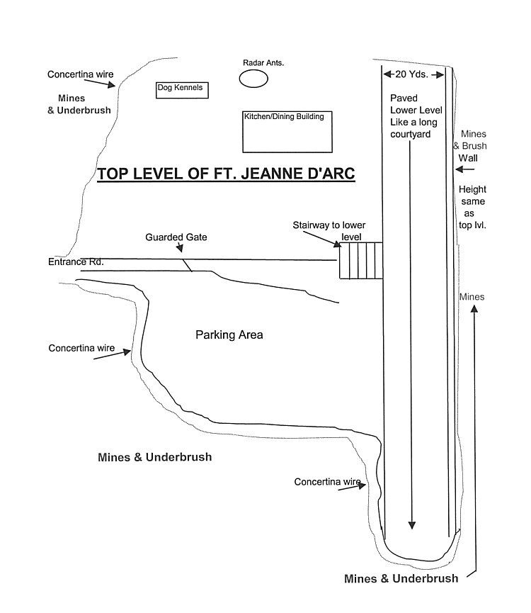
In trying to recall the layout of the fort itself (almost 40 years ago), most everyone drove to it, went through a gate guarded by FAF and parked on top. They then walked down wide cement steps with a steel handrail to the bottom level (2-3 levels) where there was one or two entrances.
On the top to the left (maybe 100 yards) of where we parked were the radar antennas, a dog kennel and run for the guard dogs (Shepards and full size Poodles). There was also a large quonset hut which housed the kitchen and dining room which was shared by all. The Chef’s name was "Wickie (excellent cook) and he had been Eisenhower’s personal chef at one time. We even had two waitresses - Michelle and Ramon. Our radio transmitter antenna towers were on the right side at the lower level of the fort. Our shop was just inside by the towers.
The bottom level was paved and ran the length of the fort and was about 20 yards wide and ended at a block/concrete wall which rose to the height of the top of the fort the same as in the parking area. Hard to explain, will try to draw a diagram at bottom. All outside the fort was concertina wire and signs everywhere that said "Danger Mines!".
There was a corridor inside that ran the length of the fort with stairs at each end to access the 2nd and/or the 3rd level. Our receiver site was maybe 300-400 yards away and we could either drive to it or walk through a tunnel to get to it. Sometimes the bulbs in the tunnel were burnt out due to constant water seepage. Although we always considered the receiver site as separate, it was connected to the main area.
I was there when on a few occasions we had groups of WW2 vets come through who had fought to take the fort back from the Germans who were occupying it. One of the stories they told was that the only way they could get the Germans out was to completely block up the sewer system and wait them out.
I have been to see the German Gate several times at the entrance to Metz - nothing spectacular. I never went to any other forts in France except Verdun where you could look in a window at ground level and see bones and skulls. I also visited some mass grave sites throughout the area.
|
Updated: August 15, 2004