SITE
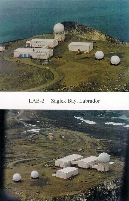
: LAB-2, SAGLEK
A. LOCATION/TERRAIN/TOPOGRAPHY
1. Location:
The site is located at the summit of Cape Uivak on the mouth of Saglek Fiord. The elevation at this point is 549 m. The geographical coordinates are: 62° 39" W, 58° 28" N. The closest source of support is the Goose Bay LSS. Flight time from the LSS is 3 hours 20 minutes by helicopter under normal conditions. A helipad is located onsite, as well as an abandoned airstrip which may be useable.
2. Terrain:
The terrain is rocky and boulder strewn. Sheer cliffs drop off to the sea around most of the summit site. The most prominent feature of the surrounding area is the Torngat Mountains, whose peaks in the area are up to 914 m above sea level. Search and Rescue is difficult due to these features. The area is typified by deep valleys and fiords with terraced glaciofluvial deposits. Small colluvial aprons and fans and alluvial terraces are present. Vegetation is scarce at the summit, consisting of lichen and a few small clumps of grass. At lower elevations, wet meadows support sedges, grasses, mosses and shrubs.
3. Topography:
Saglek is located at the foot of the Torngat Mountains, which rise steeply to the west. The area has been extensively glaciated and the site is on the edge of a Fiord.
B. CLIMATE
1. Precipitation:
Annual Average: 740 mm
Snowfall 425 cm
Rainfall 315 mm
2. Temperature:
Yearly Average Minimum: -31°C
Yearly Average Maximum: +10°C
3. Characteristics:
Heavy winds and blowing snow are normal in the winter months. Fog and rain are common during the spring and fall. Coastal waters are ice infested for much of the year.
C. SITE POPULATION
This LRR was transitioned to Unattended status on 22 September 1995. Refer to CDRL NT-10: Unmanning Transition Plan - NWS Long Range Radar Sites for details of changes to site accommodations and facilities.
D. LAND USE
LAB-2, Saglek serves the native population of coastal northern Labrador as a base camp for fishing and hunting activities. Current resource use in the area is intermittent and seasonal. The area is considered to have recreational capacity, largely due to its highly scenic qualities. No mineral deposits of any commercial significance have been found in the area although recent field surveys have been undertaken.
E. WILDLIFE
Extending inland west about 40 km from the radar station, Saglek Fiord is an important wintering ground for polar bear. Two herds of barren ground caribou range as far east as the Saglek region from the George River herd, centered 180 km west across the mountains in Quebec. Varying numbers of animals, mostly bulls, from the George River herd are present from June to September. Some members of the Torngat herd of northern Labrador, which is comprised of roughly 10,000 animals in total, are present between April and June on the northern side of Saglek Fiord, about 25 km north of the radar site where part of the herd has a calving area. In general, caribou presence on the summit radar site itself is considered rare, and only during summer months are caribou regularly seen on the slopes by the airstrip.
The marine mammal population of Saglek Fiord is an important resource. Parks Canada (1982) lists the fiord as a colony ground for beluga, whale, and a pupping area for bearded seal. Several Other seal species may be present at Saglek, including grey seal, harp seal, harbour seal, and hooded seal.
A number of other arctic mammal species are known in the Saglek area, including arctic hare, arctic fox, and wolf. Red fox may also be present and black bear is reported on occasion.
Bird species and population numbers are not believed to be extensive for the Saglek region near the radar site but available information is sparse. Common loon and red throated loon are present. Some species of sea-ducks shelter in Saglek Fiord. Common eider and old squaw nest on offshore islands. Harlequin and common merganser are frequently present. Canada geese occupy wetlands in the region during breeding season. Rock ptarmigan are common on the highlands around Saglek, and are known to breed there. Several shorebird species nest in the Saglek area, including semi-palmated plover, spotted sandpiper, solitary sandpiper, least sandpiper, and semi- sandpiper. There are small glaucous gull colonies and some black guillemot nest sites in the Saglek area but no nesting areas near the project site.
F. HERITAGE RESOURCES
Saglek Fiord is an area of archaeological importance. Sites of human occupation dating back to 6,000 years have been identified. Approximately, one hundred and fifty sites on the coastal islands, fiord shoreline, and highlands above the fiord have been isolated, but only a few have been thoroughly examined. In particular, eight historical sites near the beach within five kilometers of the base site have been identified but not fully examined. Several of these sites are within one kilometer of the LAB-2 beach area but are isolated by the steep banks of a stream. and have not been disturbed by previous military occupants.
G. WATER SUPPLY
Water from a nearby freshwater lake is pumped through a pipeline to the water tank, once annually during the summer.
H. SEWAGE DISPOSAL
Sewage is collected in a septic tank. Sludge deposited in the septic tanks is removed, as necessary, and disposed of in a sanitary landfill.
I. WASTE DISPOSAL
Domestic waste is incinerated in on-site incinerators.
J. KITS
Kit Location
1. Fire Fighting Equipment TSM, All Modules
2. Safety Boards TSM, ACC Module, RCM
3. Search and Rescue TSM
4. Disaster/Survival Emergency Shelter
5. POL Spill ATB
6. Chemical Spill TSM
7. PCB Spill TSM
8. First Aid Supplies ACC Module First Aid Room
K. POL STORAGE AND DISTRIBUTION
Tanks: Total Storage Capacity, external tanks (Litres) 2,523,536 L
1. Jet A- 1 (Aviation & PGS): Total Capacity 2,523,536 L
Total number of tanks (Steel) 9
a. Beach Area:
2 tanks 871,761 L ea 1,743,522 L
b. Building Site Area:
2 tanks 307,369 L ea 614,738 L
2 tanks 13,638 L ea 27,276 L
c. Airfield Area:
3 tanks 46,000 L ea 138,000 L
Summit fuel tanks W22C and W22D are equipped with a lined containment dyke.
Pipelines: Total Length (including building feeder lines) 5,530 m
a. 150 mm diameter pipe 650 m
b. 50 mm diameter pipe 4,880 m
Pumphouses: Total Number 2
a. Building Site Tank Area 1
b. Airfield Tank Area 1
System: Product delivered during summer marine sealift. Beach POL tanks contain sufficient tankage to accept full 27 month resupply quantity from tanker. Summit POL tankage contains sufficient storage capacity for 12 months operation. Beach POL pumping system and pipeline transfers fuel to summit POL tanks in summer only. Summit POL pumping pipeline transfers fuel to day tanks in Power Plant. Separate small fuel tankage and transfer system is provided at Emergency Shelter and Airstrip Building.
Sources Include: 1. Initial Environmental Evaluation of the North Warning System Project, Vols. 1 & 2.
Monenco- Eyretechnics Group, 1987(vol. 1), 1989(vol.2).
2. CDRL SR-03 NWS Bulk Liquid POL Facilities Report. FRONTEC, September 1999.
3. NWS Site Record Drawings
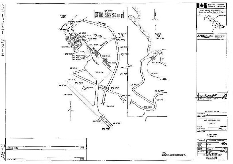
FACILITY LOCID REGISTER
LOCID# FACILITY NAME
SAG B1A Radar Communication Module Radome
SAG B2A Accommodation Building
SAG B3A Technical Services Building
SAG B4A Emergency Shelter
SAG B5A Water Storage Building
SAG B6A POL Pump House
SAG B6B POL Pump House
SAG B7A Water Pump House
SAG B9A Airstrip Terminal Building
SAG B9B Old Lower Camp
SAG B15A Storage Shed
SAG B15B Storage Shed
SAG B20C Storage Shed - POL
SAG W1 Road
SAG W2A Sanitary Sewers
SAG W2C Septic Tanks
SAG W3 Water Distribution
SAG W4A Water Storage Tank
SAG W4B Water Storage Tank
SAG W6A Power Distribution Cables
SAG W7A Illuminated Wind Cone
SAG W8 POL Distribution Lines
SAG W9A SGT Platform/Foundation Primary
SAG W9C Various Antenna Structures/Foundations
SAG W9D SGT Platform/Foundation Secondary
SAG W10 Helipad
SAG W11 Bollards
SAG W13 TVRO Foundation/Antenna
SAG W14A Weather Platforms
SAG W15A Runway Area - gravel
SAG W16A Lighting - Airfield
SAG W17A Bridge
LOCID# FACILITY NAME
SAG W18A Fences
SAG W20A POL Jet A-1 Tank, 12H
SAG W20B POL Jet A-1 Tank, 9A
SAG W20C POL Jet A-1 Tank, 1 OA
SAG W20D POL Jet A-1 Tank, 11 A
SAG W20E (Jet A-1 aviation tank), 13H
SAG W21D POL Jet A-1 Vehicle Refueller
SAG W22A Diesel Fuel Tank, 1 B
SAG W22B Diesel Fuel Tank, 2B
SAG W22C Diesel Fuel Tank, 3S
SAG W22D Diesel Fuel Tank, 4S
SAG W24A POL Jet A-1 Refueller
SAG W31 Non-Landscaped Grounds
SAG W32A Open Storage Area POL
SAG W32B Disposal Area
SAG W32C Open Storage Area
SAG W35 Containment Dyke
SAG W42A Walkway
SAG W42B Walkway
NOTE: These LOCID descriptions are currently under revision. The given Facility Name may not appropriately represent an item's current use. eg. a "Diesel Fuel Tank" now contains Jet A-1 fuel.
|
CAT I.D. |
QTY. |
NOUN |
PART NUMBER |
|
1067553 |
C/W |
POL SPILL CLEANUP KIT No. 1 |
CL006 |
|
1021477 |
20 BG |
ABSORBENT, MATERIAL 50 QT. BAG |
48210 |
|
1021572 |
10 RL |
ABSORBENT, MATERIAL 3/8" X 36" X 144 FT |
OB150 |
|
1044124 |
150 BG |
ABSORBENT, MATERIAL 50 QT. BAG |
48230 |
|
1021664 |
1 CS |
ABSORBENT,SHEET 200SIUCS 17"Xl9"X3/8"THK |
OB100 |
|
1059485 |
8 EA |
BOOM, OIL 40 FT. TOTAL LG. |
48225 |
|
1062419 |
2 EA |
PITCHFORK |
R41645 |
|
1018094 |
1 BX |
PLASTIC BAG 100 BAGS/BOX |
35-50-3B |
|
1008712 |
4 RL |
PLASTIC POLY 6 MIL, 1000 SQ.METERS |
VISQUEENCLEAR |
|
1021141 |
3 EA |
HALF MASK, DISPOSABLE TYPE |
GT-9999-3005-7 |
|
1009276 |
1 RL |
ROPE, POLYPROPYLENE 600 FT. |
MIL-R-24049 |
|
1013919 |
20 PR |
RUBBER GLOVES, LINED |
GLA513 (M) |
|
1061292 |
2 PR |
SAFETY GOGGLES |
6367 |
|
1062475 |
2 EA |
SHOVEL, ROUND MOUTH |
GGG-S-326 |
|
1022135 |
1 EA |
SLIPTANK, PORTABLE 100 GAL. |
TANK100 |
|
1003058 |
2 EA |
SALVAGE DRUMS 85 GAL. |
PS-26368 |
|
1067552 |
C/W |
CHEMICAL SPELL KIT |
CL007 |
|
1023947 |
4 PR |
COVERALLS, W/ HOOD & BOOT COVERS |
SEA PA5228 |
|
1012151 |
4 PR |
GLOVES, CHEMICAL RESISTANT |
IIIE220 |
|
1063898 |
1 BX |
RAGS, COTTON, 50 LB. |
31-25 |
|
1062334 |
4 |
SIGN, HAZARDOUS CHEMICAL |
70852 |
|
1022625 |
4 |
RESPIRATOR, HALF-FACE |
655XO13 |
|
1022622 |
12 |
CARTRIDGE FILTERS, VAPOUR |
655F155 |
|
1067554 |
C/W |
PCB SPILL RESPONSE KIT |
CL005 |
|
1023947 |
4 PR |
COVERALLS, W/ HOOD & BOOT COVERS |
SEA PA5228 |
|
1022622 |
12 |
CARTRIDGE, FILTER, RESPIRATOR |
655F155 |
|
1012151 |
4 PR |
GLOVES, CHEMICAL RESISTANT |
111E220 |
|
1022625 |
4 |
RESPIRATOR, HALF-FACE |
655X013 |
|
1062334 |
4 |
SIGN, HAZARDOUS CHEMICAL |
70852 |
|
1002984 |
1 BX |
RAGS, when exhausted use CAT ID 1063898 |
339-3420 |
|
1063898 |
1 BX |
RAGS, COTTON, 25 LB. Box |
301-10 |
Safety goggles can be found in the POL kit and on Safety Boards. Shovels and loose absorbent are provided in the POL kit.