It was the summer of 1964. The RCAF had withdrawn from the airfield at Grostenquin France. Some of the buildings at the airfield were donated to local communities in 1965 and from this point in time - what was once RCAF Station Grostenquin is a mystery.
We have been advised that the airfield was of interest to the French Air Force at the time but it appears as if no one really knew whether the airfield would ever be used again. None the less - a decision was apparently made to "keep the site".
Everyone is aware of the fact that General De Gualle had decided to withdraw from NATO. This eventually occured in 1967 and for Canada, well it meant that 1 Wing at Marville and our 1 Air Division Headquarters at Metz would have to shut down. It also meant that French NATO forces that had been serving in Germany would have to close down and return to France. Ironically, the RCAF military at 1 Wing Marville and 1 Air Division HQ in Metz moved to Lahr Germany - which was one of the locations that had previously been occupied by French military personnel.
There was always the slight chance that the French military returning from Germany could have made use of the airfield at Grostenquin (closed since 1964) and Marville (vacated in 1967) but we must not forget the fact that the USAF had also vacated many airfields in France. The returning French military were eventually repatriated to Nancy Ochey and Toul Rosières.
The airfield at Grostenquin continued to age - with "Mother Nature" taking its toll.
I returned to Europe to serve in Lahr Germany in the early summer of 1974. I made a few trips to the remains of the airfield at Grostenquin. There were guards at the main gate of the airfield and access was not generally permitted. I suppose that they were receptive to some - especially if you indicated you had once lived and worked on the airfield. I was very fortunate in being granted access and I was able to drive to may parts of the airfield. Looking back - I will always kick myself for not taking hundreds, or even thousands of photos. There were gaps here and there - places where buildings had once stood, but had subsequently been donated to local communities. The trees were growing - hey, they were 10 years older. What I remember the most is the fact that the remaining buildings had the appearance of not being maintained or used. It was as if they had just been left there for 10 years, with absolutely no maintenance whatsoever.
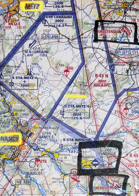
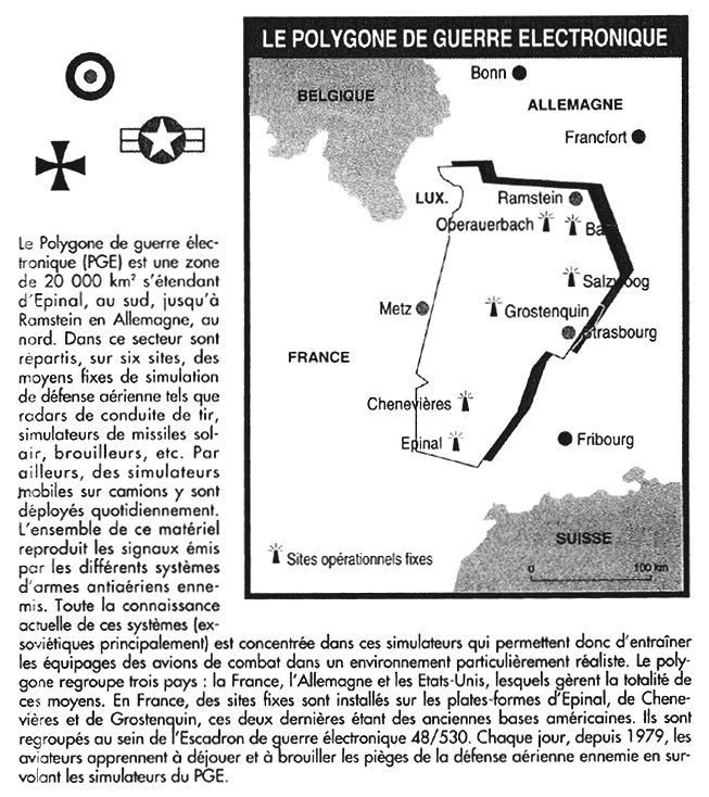
Finally in 1979, it was decided to establish an "electronic war polygon" in the east of France. This part of the sky is shared between the German, French and American air forces, where they train to simulate a hostile aerial environment. The area is centered on Grostenquin and it also makes use of the ex USAF base at Chenevières, 60 kms south of Grostenquin. It is interesting to note that the airfield at Chenevières is quite similar to that of Grostenquin from the perspective that it has not been maintained since it was closed.
The French Army arranged some old Soviet armament systems such as: missile simulator, permanent or mobile, old tanks, radar interferencers... on these two airfields. We understand that there is a ten man team at each location to operate the systems of simulation and move the trucks with weapons. These men work among ruins, in places where mother nature took back her right in the form of numerous trees and even wild animals. This explains why the area at Grostenquin is closed with a "Restricted Access" sign. There are still a lot of low flypasts of fighters at the Grostenquin airfield today, simulating air attacks and avoiding the "electronic missiles".
The "Cold War" is seemingly over - but what lies ahead in the future? How much longer will the remains at Grostenquin remain intact before someone decides is time to raze the airfield to the ground?
|
Updated: October 7, 2004