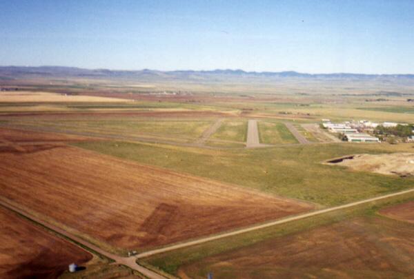
 Aerial photo facing southwest
|
|
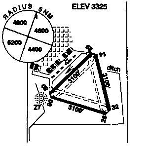 Schematic map of airfield and facilities
|
|
| Reference: July 1999 Canada Flight Supplement | |
| Lat. and Long: | North 50 deg. 00 min. 12 sec. West 113 deg. 37 min. 43 sec. |
| Location from Community: | 2.5 nm southwest of Claresholm |
| Magnetic Variation: | 18 deg. east |
| Time Zone Factor: | UTC 7(6) |
| Elevation: | 3325 feet ASL |
| Reference Aeronautical Chart: | VTA A5005 E-15 E-16 LO2 |
| Operator: | Town: 403-625-3381 Cert. (Certified Airport) |
| Public Facilities: | Available on the aerodrome: telephone. Exist within 5 nm of aerodrome: food, taxi, medical facilities, rental accommodation, car rental. |
Flight Plan:FSS |
NOTAM FILE CYQL Lethbridge 800-FSS-4710 |
Services:Oil |
All Storage available, minor repairs, major repairs, parking (extended term), tie-down facilities, plug-in facilities. |
Runway Data:RCR (Rwy conditions) |
Rwy 02 (027 deg.) / 20 (207 deg.) 3100 x 100 asphalt Rwy 08 (087 deg.) / 26 (267 deg.) 3100 x 100 asphalt Rwy 14 (147 deg.) / 32 (327 deg.) 3100 x 100 asphalt Contact: Operator, limited maintenance. |
| Lighting: | 02-(TE ME), 20-(TE ME) ARCAL-123.0 type K Taxiways and ramps reflective markers only. |
Communications:ATF |
unicom limited hours O/T tfc 123.0, 5 nm 6300 feet ASL. |
Navigation Aids:NDB |
Z7 408 (M) N50 00 10 W113 38 13 at Aerodrome Private Unmonitored |
| Cautions: | Glider activity. |