|
What ever happened to the second runway at Frobisher Bay? Thanks to Robert Eno, we have the "rest of the story".
Excerpts from a JAINA Paper with additional comments from Robert Eno
Construction of the airfield at Frobisher Bay commenced in 1942. By September, the airfield had developed into a bustling community. A hospital had been built, as well as living quarters for the workers, a canteen, workshops, garages, warehouses, and a small tent city. The well-paid men amused themselves in their off-hours with poker games, where large sums of money were won and lost, and the occasional movie. Heavy equipment moved about the community as they built roads and, most importantly, the airfield facilities.
Construction work on the airbase continued throughout the winter of 1942-43. By the end of 1942, two gravel runways had been laid out: Runway No. 1, a 6,000 foot runway oriented northwest to southeast, and Runway No. 2, a 5,000 foot runway oriented northeast to southwest. Both runways were initially at a width of 150 feet. By April 1943, both were operational, though not fully developed.
Work on the airfield continued at a steady pace. Extensive blasting was required to obtain aggregate material for construction of the runways. The engineers and builders were plagued by problems related to permafrost. At the time, the Americans had very little experience in working under such conditions. Washouts were frequent, sometimes resulting in gullies as deep as 5 m cutting across one or the other of the two runways. Water would often well up from below the surface, creating gaping holes that had to be filled with rocks and smoothed over. Maintaining the runways was a constant battle, but in the end the US Army prevailed, often through brute force. In October 1943, the groundwork had been laid, and the base was well on the way to completion.
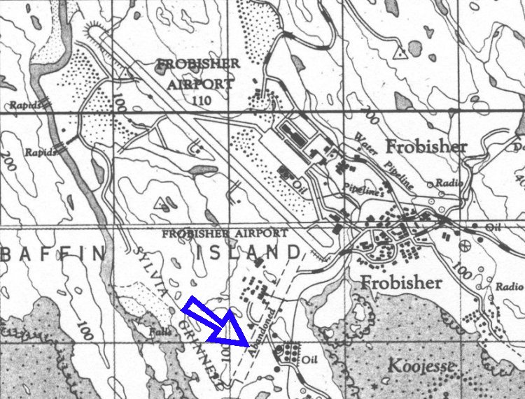
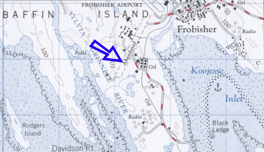
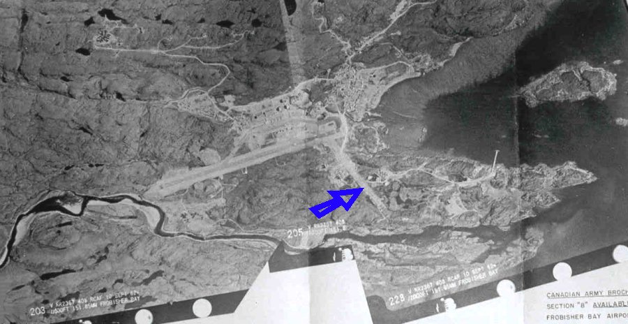
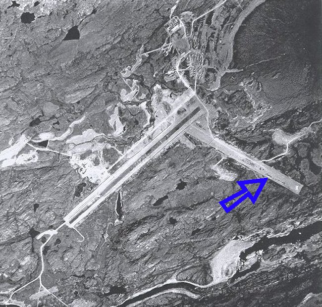
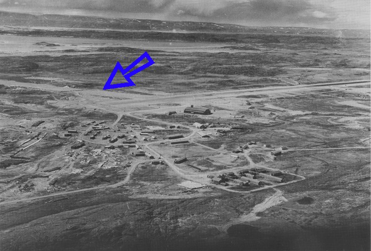
By the end of 1943, the airfield, which included the two runways - No. 1 (paved) and No. 2 (gravel), a 30,000 square foot aircraft hangar and a control tower, was fully operational. However, the Americans continued to experience permafrost-related problems with both runways, which required constant maintenance and repairs. Runway No. 2 runway was gravel and it was used for a very brief period of time; maybe two or three years but only sporadically. In fact, it may have been the first runway to be used at Frobisher Bay while the engineers were finishing off the main runway. Runway 2 was never paved and was never inteded to be, however, Runway 1 was paved during the war and then re-paved a few times after that. Runway 1 is what is indicated on current day airfield diagrams as 18-36.
Runway No. 2 was initially intended for use as an emergency runway. Later, however, it was found to poorly oriented with respect to the prevailing northwest winds; moreover, it was subject to takeoff and landing restrictions imposed by the surrounding topography. The USAAF knew what the prevailing winds were (NW or SE) and therefore it was always intended that Runway 1 (the existing operational runway) was to be the main runway. Even as early as April 1943, it was suspected that Runway No. 2 was not a very encouraging prospect, although at the time the Americans continued with its development. A ridge 122 m high obstructed the northeast approach, making takeoffs and landings to and from that direction difficult and sometimes dangerous. Aircraft always had to approach the runway from the southwest and take off towards the same direction. Additionally, a rock ridge 6 m high along the north edge of the runway, about midway along its length, further limited its use. By mid 1944, further development on Runway No. 2 had been discontinued, and eventually it was abandoned altogether. The runway did prove useful, however, as a parking area for aircraft and vehicles and a storage area for drummed fuel.
In June 1944, the Canadian Government purchased the airfield at Frobisher Bay from the Americans for $6.8 million. Canada was becoming increasingly concerned about the American military presence on Canadian soil, and was anxious to regain control of its northern territories. It was not until September 1950, however, that the Canadians actually assumed official control of the airfield when the RCAF started to provide Air Traffic Control services and the sign on the control tower was changed to read "RCAF Frobisher Bay".
In 1954, the Americans began blasting away a rock ridge which had long been considered a hazard to air navigation-located several hundred metres off the northwest end of Runway No. 1. By 1960, the runway had been completely rebuilt (using the crushed rock from the removal of that ridge), lengthened from 6000 to 9000 feet and expanded in width from 150 feet to 200 feet. The new runway was also re-surfaced with a new coat of asphalt. Operation of the airfield was eventually transferred from the RCAF to the Canadian Department of Transport (DOT), late in 1957, who would operate it as a civilian airport.
Runway 2 has been unusable for quite a few years - at least since 1950. The new airport was built at the NE end of it and in the mid eighties, the North Warning System constructed a barracks and radar installation on it. The rest of it is being used for dogteams and shacks and there are a few industrial buildings as well. When I first arrived here in 1988, you could clearly see that there was a runway as there was nothing at all constructed on it. It was rather interesting to see. Everyone kept telling me that this was the first runway and that Runway 1 was constructed after Runway 2, but no one had anything with which to back up their assertions. They'd heard it from someone else.
The last vestiges of the wartime origins at Frobisher Bay are slowly disappearing. The extreme northeast end of Runway No. 2 - which, some evidence suggests, might have been the first runway to be constructed at Frobisher Bay is now occupied by the current airport terminal building and a parking lot. The southwest end of this original runway is still discernible, but it is slowly being built over. It no longer resembles a runway, but looks more like a wide gravel road. At least one building can trace its origins to the Second World War - the original aircraft hangar, built in 1943, which served as Frobisher Bay's airport terminal until it was replaced by a more modern facility in 1985-86. Shortly thereafter, it was purchased by First Air for use as an office and cargo shed. First Air recently renovated the hangar, which bodes well for its future as a preserved historic landmark. Unfortunately, the original control tower had to be demolished.
Updated: March 17, 2005